
By Rob Jansen
Mountains: San Luis Peak (14,014′), Wetterhorn Peak (14,015′), Uncompahgre Peak (14,309′), El Diente Peak (14,159′)
Climbers: Dillon Sarnelli, Rob Jansen
Dates: July 4 – 6, 2012
Trip Totals: 50.5 miles, 17,300′ vertical
Note: Originally posted on 14ers.com. Most timestamps have been removed.
I ran the Leadville Trail Marathon on Saturday, June 30th. It hurt. A lot. In fact, now that I’ve had a few days to think about it, I’d say it was easily the most painful thing I’ve done in my life. That race and it’s quad-crushing hills left me battered heading into an abbreviated July 4th work week.
Some time during this past winter, I found myself scheming as to how I would complete the rest of the San Juan 14ers this summer. They presented a gaping hole in my 14er resume, as they aren’t easily doable in a day from Denver, and the layout of the range presents challenges in driving from trailhead to trailhead.
With July 4th being on a Wednesday, I knew a long San Juan weekend would have to follow the marathon. I put out feelers to some fellow climbers, and after a few weeks of discussion, Dillon was the last man standing. His first San Juan 14ers had come in the form of Mount Wilson and Wilson Peak over Memorial Day weekend, and I knew he’d be excited to get back to this area. The two of us tend to move pretty quickly, and I figured we’d have a good chance at knocking off all four peaks with some decent weather. Only one problem, Mother Nature had other plans. The forecast for all three days looked like this:
Showers and thunderstorms likely. Some of the storms could produce heavy rainfall. Cloudy, with a high near 61. South southeast wind around 10 mph. Chance of precipitation is 70%. New rainfall amounts between a quarter and half of an inch possible.
Still, knowing that the forecast can sometimes be wrong, and not wanting to cancel the entire trip solely because of NOAA’s musings, we roared out of Denver Tuesday afternoon bound for Creede, and San Luis Peak.
After a five hour drive and the most difficult trailhead search I’ve ever been a part of, we were sawing wood by 11pm, with alarms set for 5am.
*All photos with date and time stamps taken by Dillon
Wednesday, July 4th – San Luis Peak (14,014′) and Wetterhorn Peak (14,015′) attempt:
The alarms could not have come soon enough, as I had shivered through the night in my eight year old North Face Cat’s Meow sleeping bag. I think Dillon was slightly more comfortable in the passengers seat of the car. Some granola and breakfast bars, a last minute gear check, and we were on our way, with the weather looking good.

Soon we found ourselves at the saddle above the basin, with a junction that didn’t match USAKeller’s route description. Luckily, there was a helpful hint at our feet.


We contoured around two separate drainages on the undulating trail before approaching the final saddle. This route is incredibly pleasant, and begs to be run. If only it weren’t so remote.


We meandered up the final scree slopes, and found ourselves atop San Luis shortly after 8 AM.


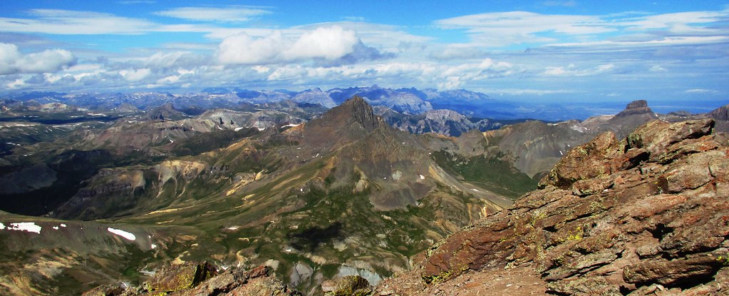
We met four other hikers who had ascended from Stewart Creek. One of them remarked how he doesn’t think there is another spot in Colorado where you can see so much without a single road. I haven’t visited Chicago Basin yet, but this is still an amazing spot in this regard.


We coasted down into Creede to join in the July 4th celebration at Kips Grill. After a couple of recovery beverages and some fantastic tacos, we hit the road for Slumgullion Pass and Lake City.
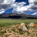
The drive north on CO 149 was filled with heavy downpours. It seemed Mother Nature was proving NOAA correct, as we rolled into Lake City and took shelter in an internet coffee shop with steady rain falling in town. We charged our phones, picked up a few groceries, and started up the Alpine Loop for the Matterhorn Creek trailhead around 3:30 PM. By the time we arrived at the base of the 4wd road (we parked 0.7 miles below the TH), the rain had stopped and we had a pleasant time setting camp.
As the clouds broke and the sun began to poke through, we sat in the car and discussed what had been a successful first day. Quickly though, our thoughts turned to our ambitious Thursday itinerary. Wetterhorn and Uncompahgre from Matterhorn Creek as a day hike. While we were both feeling fresh after the mellow climb of San Luis, our concern, again, was the forecast:
Showers and thunderstorms likely. Cloudy, with a high near 58. South southeast wind around 15 mph. Chance of precipitation is 70%. New rainfall amounts between a tenth and quarter of an inch, except higher amounts possible in thunderstorms.
“How are we going to pull off the double with a forecast like that?”
“Well, we have to start early, move quickly and be ready to turn when the weather dictates. Just have to play the hand Mother Nature deals us really.”
This conversation continued for a few minutes. Eventually, though, as is bound to happen with the two of us, our eyes turned to the sky and our heads grew. In short, we decided that 8.4 miles (from the lower TH, where we were), and 3700′ wouldn’t be too taxing with light packs, and we decided to make an attempt on Wetterhorn then, with a conservative approach and expectations for nothing more than a simple scouting mission.
We departed the trailhead at 5:30 PM, and hiked the 0.7 miles to the upper TH in 12 minutes.

We debated the weather, and while there was a cloud layer above the peaks, it wasn’t threatening. I had some concern, but we decided to push on and turn if we hadn’t reached the summit in a timely manner.

We approached the yellow portion of the ridge, and suddenly a few drops of rain began to fall. A quick glance at Uncompahgre made for an easy decision, especially considering neither of us had been up Wetterhorn before.

It took us an hour to get back to the car, where we promptly went horizontal in anticipation of a 3:30 AM start. Despite the weather that evening and rain overnight, we were confident that an early start and quick pace might net one summit. The forecast:
Showers and thunderstorms likely. Some of the storms could produce heavy rainfall. Cloudy, with a high near 57. South southeast wind around 10 mph. Chance of precipitation is 70%. New rainfall amounts between a quarter and half of an inch possible.
“If there is a weather window, we will be there for it,” were the final words as we headed to bed. A 7000′, 17 mile day in the books.
Thursday, July 5th – Wetterhorn Peak (14,015′) and Uncompahgre Peak (14,309′) from Matterhorn Creek:
Up like a shot at 3am, we were quickly dressed and hiking at 3:30am. Dillon, having slept in the car again, informed me that an hour of steady rain had let up just minutes before we woke. With the skies partly clear, we cranked it up the 4wd road, once again making the 0.7 miles in 12 minutes.

We made quick work of the approach and boulderfield, arriving at the ridge on Wetterhorn after nearly 90 minutes. The skies were a mix of cirrus clouds and clear, and we quickly approached the class 3 portion of the climb. Trekking poles were stashed, helmets donned, and the fun began.


There was less class 3 on this climb than I anticipated. It can be kept almost entirely class 2/2+ with the exception of the final ~200 feet to the summit. The scrambling ended before it had even began, and we reached the summit just before 6am.


We lost helmets, retrieved poles, and wove through the boulderfield. Dillon was able to spot a game trail that appeared to take a high contour towards the saddle with Uncompahgre. I believe it is the same trail mentioned by Dancesatmoonrise in his “Half Cup O’ San Juan” report.

The route to the saddle is pure joy. A gradual, soft trail leads toward the hulking mass of Uncompahgre, and it grows quickly as you draw near.


We saw not a soul on Wetterhorn, but must have passed fifteen folks on our way up the monarch of the San Juans. The elevation gain melts away quickly on this gentle route.


With our eyes to the west, we climbed toward Uncompahgre as quickly as our legs would allow. After a loose class 2 section, the route levels off and the broad summit comes into view. We reached the roof of the San Juans at 9:20am, about 3:10 after leaving the summit of Wetterhorn. Once again, Mother Nature was giving us a window.


We departed Uncompahre around 9:45am, and exchanged words with several parties who were heading for the summit. It was a pleasant walk back to the Ridge Stock Trail, which we followed back to the saddle. We dropped back toward Matterhorn Creek under darkening skies, and hit the trees just as the first drops of rain began to fall. We reached the trailhead at 12:30pm, for a round trip time of exactly nine hours. Rain started to fall as we drove back into Lake City, and we discussed how fortunate we had been to hit the weather window perfectly.
With just one peak left on the agenda, we hit the road for Telluride and the South Slopes of El Diente Peak. The drive via 149 and 50 was long, and we got slammed by a torrential thunderstorm while passing through Montrose. No views of Sneffels were to be had while passing over Dallas Divide, and a steady rain greeted us as we pulled into Telluride.
After re-fueling at Brown Dog Pizza, picking up some last minute supplies and verifying the trailhead directions (thanks gonzalj!), we took 145 south over Lizard Head Pass. As we descended, the rain stopped and we were surprised to actually get a view of Lizard Head itself. The dirt road to the South Slopes trailhead is easily doable in any vehicle, and as we pulled into the parking lot, El Diente Peak stared us down under ominous skies.

Friday, July 6th – El Diente Peak via the South Slopes from Kilpacker:
Knowing that El Diente was the last peak on the agenda helped pull us from our slumber, and I poked my head out of my tent to see mostly cloudy skies. Only a pale gray was visible as the moon sat behind the clouds. As we geared up, I had a sinking feeling in my stomach that Mother Nature was going to end our lucky streak today. The forecast, again:
Showers and thunderstorms likely. Cloudy, with a high near 59. South southeast wind around 15 mph. Chance of precipitation is 70%. New rainfall amounts between a tenth and quarter of an inch, except higher amounts possible in thunderstorms.
We set off at 5am, and followed the gentle trail 2.25 miles through meadows and forests to the following sign. The left option goes toward Navajo Lake, while right leads into Kilpacker Basin. I think we covered these first few miles in ~45 minutes; the trail couldn’t be much more friendly.

We knew that we had only gained 200′ of elevation in the first 2.25 miles, and were fully prepared for El Diente to bring on the pain. Before getting down to business though, another half mile must be traveled, where you’ll cross Kilpacker Creek and get the classic shot of El Diente with it’s waterfall.

The Peak drifted in and out of the clouds as we ascended. As we watched the weather, it appeared that the high level clouds were moving east, while low level clouds rushed in and out of the basin. As they were still broken and appeared unorganized, we decided to continue upward


The elevation gain comes quickly as you ascend the scree, and before long we were beneath the Organ Pipes, staring up toward the notch in the ridge. Another quick check with the weather showed that is was still the same as it had been all morning. With broken clouds around the Wilson massif but a persistent cap sitting over El Diente, and no indications of storms or precipitation in the vicinity, we scrambled quickly to the ridge. Dipping toward the north side of the mountain, we found ourselves on the summit at 8:30am, just a few feet up into the clouds.


We carefully picked our way down the upper route, and soon enough had reached safer ground in the basin. Removing our helmets and taking a moment to relax, we looked back to El Diente, thankful for safe passage on a dangerous route. The weather was still holding, and the summit had come out of the clouds.
Careful to not roll any ankles, we hiked out of the basin, admiring the low clouds that continued to play just above the basin. I’ve switched to trail shoes for most summer climbs, but the rock along this route is terrible, and I was glad to have my boots.
With ~46 miles and 17,300′ of vertical on our legs in just over 48 hours, Dillon somehow still had energy to burn. I convinced him to attempt a first ascend of El Diente’s sibling, this 4′ high rock outcropping in the basin.


Back at the trailhead at noon, about 7 hours for the round-trip.


After 50.5 miles, 17,300′, 4 new summits, and a whole lot of worrying about the weather, we enjoyed Dales on a cool summer afternoon at the Kilpacker Trailhead before heading into Telluride for Mexican food at Emillio’s.
This was an incredible few days in the San Juans and a great way to spend part of this long weekend. I think Dillon and I both learned just how valuable early starts can be, as we just snuck these mountains in while dodging some of Mother Nature’s own fireworks. Here’s to seeing everyone in the hills again soon!
Robert
